
An Australian and international research voyage has mapped a highly energetic "hotspot" in the world's strongest current simultaneously by ship and satellite, and uncovered an underwater mountain range.
Halfway between Tasmania and Antarctica, the block of the Southern Ocean surveyed in high-resolution, three-dimensional detail stretches over an area of 20,000 square kilometres down through layers of swirling currents to the seafloor 4,000 metres below.
The FOCUS voyage on the Commonwealth Scientific and Industrial Research Organisation (CSIRO) research vessel Investigator has been working in the Antarctic Circumpolar Current to understand how heat leaking across this natural barrier contributes to melting Antarctic ice shelves and the potential for sea-level rise.
The voyage was designed to work with the new Surface Water and Ocean Topography (SWOT) satellite, jointly developed by NASA and the French space agency Centre National d'Études Spatiales (CNES) to enable simultaneous mapping of fine-scale ocean features from the satellite and the ship.
Voyage chief scientist Dr Benoit Legresy said CSIRO and the Australian Antarctic Program Partnership worked with collaborators and equipment from the US and France to tackle important climate questions.
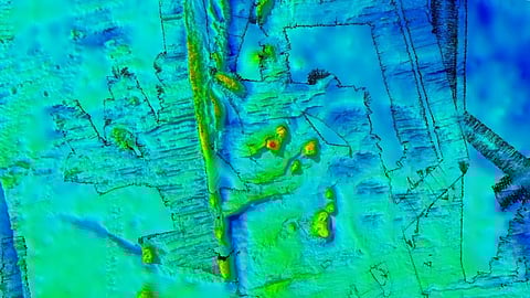
While mapping the ocean currents, the companion mapping of the sea floor bathymetry has revealed ancient dormant underwater volcanoes.
CSIRO geophysicist Dr Chris Yule said the team conducted high resolution mapping with Investigator's multibeam echosounder system. The survey spanned a seafloor area of 20,000 square kilometres, most of which has not been mapped before.
Among the features discovered are a chain of ancient seamounts comprising eight long-dormant volcanoes with peaks up to 1,500 metres high and one with a double vent.
The survey area is 200 nautical miles west of Macquarie Island and the tectonically active Macquarie Ridge. The seamounts were formed by volcanoes arising from hot-spot magmatism within the last 20 million years.
Voyage co-chief scientist Dr Helen Phillips, from the Australian Antarctic Program Partnership at the University of Tasmania, said new discoveries about the shape of the seafloor are vitally important to understanding ocean dynamics.
The data collected from the voyage will be analysed by principal investigators in Australia, the United States, and France to inform their research on the Antarctic Circumpolar Current and its role in global warming effects on Antarctica.
