
An archaeological mission under the auspices of UNESCO recently concluded its 14-day exploration of the Mediterranean Sea, particularly the Skerki Bank off Tunisia and the Sicilian Channel in Italy. In that exploration, international scientists from eight member states have modeled a number of shipwrecks and improved the mapping of the area in order to protect important underwater cultural heritage sites.
Researchers from Algeria, Croatia, Egypt, France, Italy, Morocco, Spain, and Tunisia collaborated for this mission, which took place over 14 days aboard the French scientific vessel Alfred Merlin.
The mapping was conducted in international waters, on the Italian continental shelf, under the coordination of Italy, and then on the Tunisian continental shelf under the coordination of Tunisia.
The Skerki Bank is located in the Sicilian Channel/Canal du Cap-Bon in the Mediterranean Sea. UNESCO said that over the centuries, this area played an essential role in the military, commercial, cultural, and religious dialogue of the Mediterranean basin.
As it is located between the western and eastern basins of the Mediterranean and the south and the north of this sea, it is a point of contact between many cultures of the Mediterranean. It is located on a very busy maritime trade route used from Antiquity to today, where several wars have also played out.
Dozens of wrecks have already been located in the area of the Skerki Bank, including four that were sunk during the Second World War and two during the First World War. Some shipwrecks were rediscovered by American archaeologists Robert Ballard in 1988 and Anna Marguerite McCann in 1997. Together, the expeditions located eight wrecks and one ancient trade route on the high seas between Carthage (now part of Tunisia's Tunis Governate) and Rome.
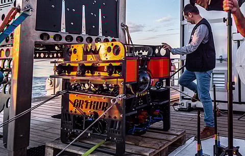
The archaeologists led a survey using two different remotely operated vehicles (ROVs), adapting to the geographical and morphological submerged areas. The ROV Arthur, designed especially for archaeological surveys in deep waters, was used to document shipwrecks on the Italian continental shelf.
Arthur documented three Roman shipwrecks discovered by the Ballard and McCann expeditions in the 1980s and 1990s. UNESCO said the archaeologists were happy to find that the state of conservation of these shipwrecks and artefacts is almost the same as it was nearly 30 years ago; they have not been impacted by sedimentation, bio-erosion or human activities (fishing nets, etc.).
The new data collected allows for higher resolution photos and videos that help to characterise and date the ships' cargo. Documenting these sites has uncovered substantial new evidence.
On the Tunisian continental shelf, the archaeologists used the ROV Hilarion to verify and document the targets of the newly mapped area. The seabed was also explored with multibeam sonar to give more information about this area, which is unknown and dangerous for navigation, and on the potential location of other archaeological remains.
The area around the Keith Reef was scanned for the first time in order to produce a detailed map showing the traces of underwater cultural heritage. This allowed the scientific and technical team to document three new shipwrecks dating from the Ancient to the Modern period (19th century), as well as several other areas of archaeological interest.
This autumn, the archaeologists will meet at UNESCO to unveil their preliminary findings. A full, detailed report will be presented at a later date.
The archaeologists plan to process the photogrammetry of the revisited wrecks located on the Italian continental shelf, using the video taken by the ROVs and recommend continuing the mapping of the Skerki Bank area on the Tunisian continental shelf. They also want to organise several activities such as a scientific conference, follow-up missions, and a reflection on the protection of these sites.
