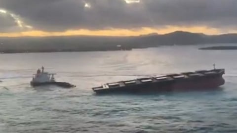

It is a terrible thing to see, a big ship wrecked and torn apart by a remorseless ocean. The miserable pictures of the giant bulker on the once pristine shores of Mauritius show a grim sequence of a grounding that initially did not look that calamitous, then with each day passing the situation inexorably deteriorating. First the Indian Ocean swell took charge and spun the empty ship on her axis to ground the stern, then, with the bunker tanks breached, the deteriorating weather broke her back and tore the whole cargo section adrift from the remainder of the vessel.
The sheer scale of the incident was what surprised me, with this being a nearly new Capesize vessel, but there is no arguing with the sea, whatever the size of ship. Only the aerial pictures of the grounded bulker, and the miniscule tugs, gave a sense of proportion. And while this was an empty dry cargo ship (neither a tanker nor a containership as it has been identified by mainstream media), there was sufficient heavy oil on board to make the most awful mess of beaches, mangroves and coral reefs, on an island renowned for its natural wonders.
Well, they have hauled the forepart off for scuttling in deep water and there will be months of work for the wreck removal team, but now the focus will be on cleaning up the mess and determining the sequence of events that put this ship ashore. The flag state of the Japanese-controlled ship was Panama, an authority not renowned for the transparency of its accident investigation, but it is clear that the Mauritian authorities will be pursuing their own enquiries, by means of criminal charges laid against the master and one of the deck officers.
Why on earth was this large and well-equipped ship, on her ballast passage from China to Brazil, passing so close to this island? In the days when navigators depended upon celestial fixes, it would be not uncommon to close an island to verify the ship's position, but those days are long gone.
Might the vessel's electronic navigation system have been playing up? It wouldn't have been the first time such an accident happened. Some years ago, a modern, fully equipped ship ploughed into an island off Tristan da Cunha in the South Atlantic because her electronic chart system had somehow "edited out" the presence of this obstruction on the vessel's passage plan.
A large containership, according to the subsequent accident investigation, grounded on a shoal in the English Channel, simply because her electronic course had been laid right across the shallow water and nobody had noticed. Indeed it was only when the coastguard politely enquired why the ship had stopped that they realised that they were aground.
There is no shortage of this sort of accident, contributed to by over-confidence in the clever equipment, failure to use alternative position-finding checks such as those offered by eyes and wheelhouse windows, and what is often described as complacency.
It is simplicity itself to plot a vessel's courses into the system, compared to the old ways of laboriously hauling around paper charts, employing pencils, dividers, the old roller rule, notices to mariners, tide tables, and navigational warnings. Maybe it was easier to check when the poor old Second Mate had mixed up the scale of the chart and put the ship five miles off rather than ten (guilty plea here).
Might both the ease of establishing a ship's position and the illusion of absolute accuracy given by those friendly satellites, sometimes contribute to errors directing a ship into danger? A couple of days with no sights and you certainly would not rely upon your dead reckoning position. But people really do rely on their GPS and the instant and trouble-free precision of its navigation, despite the regular warnings that they shouldn't.
"We know exactly where we are," says the master to the pilot, who actually points out that there is a potentially lethal offset in the ship's GPS, which can be verified by the pilot's PPU, backed up by the good old Mk I eyeball.
But if complacency, or arrogance, or a mistaken idea of precision conferred by super technology, helped to drive the ship up on the beach, it might, as has been hinted, be the curse of communications that was a major contributor to this oil-smeared disaster. Ships on their long, slow, deep-sea passages these days will sometimes close an island so that the crew can chat to their nearest and dearest on their mobile phones. Here again, we are reminded of several other navigational accidents caused because of the preoccupation of a navigator with a cellphone conversation.
Mindful of this, sensible masters and managers will closely regulate the use of personal devices on the bridge of a ship, mindful of the range of diversionary entertainment that might cause the watchkeepers to neglect their duties. But these accidents still happen. If the technology is available, the chances are that somebody will use it.
And we shouldn't fall into the trap of condemning modern technology, rather than the stupidity of those who use it badly. But there is no getting away from the fact that while in the bad old days accidents regrettably happened, the sort of mess on the beaches of Mauritius is quite inexcusable.
