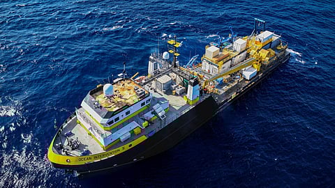
Oceaneering International's subsea robotics segment has upgraded the oceanographic research vessel Ocean Intervention II to enable it to perform simultaneous autonomous survey operations.
Launched in 2000, Ocean Intervention II was purpose-built for geophysical and geotechnical surveys. In early 2025, the vessel underwent a series of upgrades to expand its capabilities and improve performance for modern survey demands.
Enhancements include: including hull-mounted sensor expansions and a full overhaul of navigation and positioning systems; installation of a dedicated launch and recovery system for safe deployment and retrieval of unmanned surface vehicles (USVs) and autonomous underwater vehicles (AUVs); computer rack room retrofits and integration with cloud-based services for data processing and analysis; and engine room modernisation to improve reliability and to extend vessel life.
Oceaneering said that, with its enhanced configuration, Ocean Intervention II can seamlessly transition between AUV and towed geophysical surveys as well as geotechnical sampling to support multi-discipline survey campaigns.
"Ocean Intervention II provides a step change in survey data acquisition productivity with the ability to simultaneously collect AUV, towed geophysical, and geotechnical data," said Peter Buchanan Sr, Oceaneering's Director for Survey, Products and Services, Subsea Robotics.
"We’re excited to offer this enhanced capability to our clients."
Oceaneering said that pairing with the company's remotely operated USV capabilities and global onshore remote operations centres would enable Ocean Intervention II to support faster data acquisition, improved decision-making, and increased efficiency through simultaneous operations.

