A multinational expedition led by non-profit Ocean Exploration Trust aboard the exploration vessel Nautilus has completed an archaeological survey of more than a dozen World War II-era shipwrecks in Iron Bottom Sound in the Solomon Islands.
During the 22-day mission, which included the visual identification of multiple historically significant vessels, the team surveyed 13 wreck sites, including four ships documented for the first time.
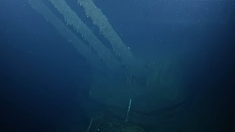
Among the newly identified wrecks are the bow of the heavy cruiser USS New Orleans and the Imperial Japanese Navy destroyer Teruzuki, both lost during the naval battles in the Guadalcanal campaign.
Other vessels surveyed in high resolution include the US Navy cruisers USS Vincennes, USS Astoria, USS Quincy, and USS Northampton; the US Navy destroyers USS Laffey, USS DeHaven, USS Preston and USS Walke; the Royal Australian Navy cruiser HMAS Canberra; the Imperial Japanese Navy destroyer Yudachi; and an unidentified landing barge.
“It was wonderful to return to Iron Bottom Sound, where we discovered Japanese, Australian, and American warships over 34 years ago,” said Dr. Robert Ballard, President of the Ocean Exploration Trust.
“This expedition was special, allowing us to film these sites in a manner not possible back then, as well as document other ships, while at the same time sharing our work live to the entire world.”
The surveys were conducted using advanced underwater robotic systems, including remotely operated vehicles (ROVs) deployed from Nautilus and the uncrewed surface vehicle (USV) DriX, which was operated remotely from a shore-based station in Honiara.
The USV, developed by the University of New Hampshire, mapped over 1,000 square kilometres of seafloor, producing the highest-resolution maps of Iron Bottom Sound to date and identifying dozens of potential targets.
“The use of our uncrewed vessel allowed a tremendous increase in exploration efficiency as we were able to continuously map and identify potential targets while Nautilus was deploying its ROVs,” said Dr Larry Mayer, Director, Center for Coastal and Ocean Mapping at the University of New Hampshire.
“This technological achievement, combined with the tremendous historical significance of our discoveries, made this one of the most rewarding missions I have ever participated in.”
Iron Bottom Sound, situated between Guadalcanal, Savo, and Nggela Islands, was the site of five major naval battles between August and December 1942. More than 111 vessels and 1,450 aircraft were lost during the campaign, with over 20,000 lives lost. Dozens of wrecks still remain undiscovered.
The expedition streamed over 138 hours of ROV dives live via NautilusLive.org, bringing real-time exploration to millions of viewers worldwide, including veterans, descendants, and historians.
Using telepresence technology, more than 130 experts from the United States, Japan, Australia, New Zealand, and other nations contributed remote analysis and historical interpretation during operations.

