GeoEye, a US-based provider of satellite and aerial-based geospatial information, has announced the release of OrbMap 7 software, featuring three dimensional (3D) views of oceanographic maps.
OrbMap software is a key component of the SeaStar Fisheries Information Service that provides information to support commercial and recreational fishing captains worldwide.
GeoEye collects, processes and transmits satellite imagery products, in the form of digital oceanographic maps, to fishing vessels worldwide, which the captains then view and manipulate using the OrbMap software on their vessel's personal computer. By using the SeaStar Service with OrbMap software, fishing captains can better determine where to move their vessel, minimising search time and reducing high vessel operating and fuel costs.
OrbMap 7 now allows users to display C-Map Max Pro navigational charts. This is the latest evolution in C-Map charts from Jeppesen Marine and is an advanced electronic charting standard for the light marine market.
With a license key, one can unlock detailed bathymetric contour data, seamounts, ridges and other navigational information in the charts as well as allow captains to purchase lower scale charts.
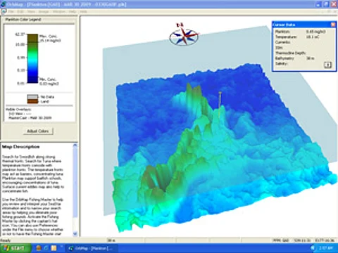
Buoys and vessel GPS position tracks, catch locations and waypoints can all be displayed in various combinations with these charts. OrbMap 7 allows 3D viewing of all the oceanographic base maps such as plankton, sea surface temperature and thermocline depth maps.

The base maps can now be rotated to view all sides, showing peaks and valleys where the height is related to the data value. This is useful for detecting regions where the conditions and fronts change quickly with a perspective previously not possible. For example, the vertical changes that occur in the water column are readily apparent in the thermocline depth map.
OrbMap 7 adds maps showing the surface salinity which are available daily, allowing captains to observe river water plumes, water mass convergence zones, and surface fronts, all important for surface fish distribution.
OrbMap 7 has linked GeoEye's exclusive MasterCast analysis tool with the fish catch database so that all the ocean variables from the catch location are recorded with the fish catch information and can be used to find similar conditions at a later date. Captains can calibrate the MasterCast by selecting good locations on the maps and even using the conditions where they observe other vessels or the location of one of their buoys.
For further information contact:
